Every so often in our travels we come across a tiny quirk, a twist in the tail, or unexpected opportunity. The hiking trails of Gyeongju’s Mt Namsan was one such experience.
Ask anyone what a typical hike will consist of and I’m sure you’ll get some very similar responses…walking, trees, mountains, occasional wildlife…
While it never seems to get boring for us, I can empathise with those who see it as a rather tedious past time! Now the funny thing is that I suspect many of these very same people would actually prefer to spend a day wandering the art galleries of Paris, or perhaps the ruins of the Roman Empire.
What if I was to tell you that you could actually achieve both?!
That’s right, a breath-taking hike in the Korean wilderness, while simultaneously exploring dozens of ancient Buddhist relics and holy sites up to 1000 years old?!
We’d never come across anything like it before, but the network of hiking trails that criss-cross the Gyeongju National Park provide such an experience for locals and tourists alike.
We were staying in the fantastically gaudy, yet perfectly situated Sugar Hotel, so we started out by taking the #500 bus from town, listening intently for the English announcement telling us that our next stop was for the Samneung Tombs. We don’t normally get a greeting party, but in this case it consisted of a single old Korean bloke helpfully waving at us in an effort, we think, to tell us that the start of the hike was just across the road.
It looked suspiciously like a dodgy trail to nowhere…so we declined his assistance and walked back up the road to realise almost immediately that the tourist information booth, and absolutely massive entry point to the hiking trail (how we didn’t see that while seated on the bus I have no idea!!), were only 30 metres away.

Start of the Mt Namsan hike
Literally less than 50m into the hike (just past that hut in the photo above) and we both nearly shat ourselves when a small green snake slithered across the path, only a footstep away!! A bit of research tells us that this was actually a Rhabdophis tigrinus, or ‘tiger keelback’ snake, and it’s quite unusual in that it eats poisonous toads, storing the poison in its neck which it can puff up to act as a deterrent to other predators. Believe me, academic explanations were of no interest to us both as we scuttled past at some speed!!

Rhabdophis tigrinus, or tiger keelback snake
As mentioned already, the trails in this park are many and varied, so we took a small detour to the left to make the short walk up to the Mangwolsa Temple.
Loved the artwork on the doors to this temple. Really striking.

Mangwolsa Temple, Mt Namsan

Mangwolsa Temple, Mt Namsan
Walking back to the main trail, we passed the Samneung Royal Tombs, before commencing a pretty epic hike up the mountain range.

Samneung Royal Tombs

Mt Namsan hiking map
The next one and half hours or so were pretty brutal for myself. I’m not sure if it was dehydration, the humidity, fatigue or a just a massive princess complex, but I really struggled up that mountainside!
What really helped though was the fact that every 10 to 15 minutes you would stumble across either a statue of Buddha, a pagoda or a stunning relief carved into the hard stone of Mt Namsan.
I won’t give a blow by blow account, but here are the best of those we encountered on the ascent…

My head, my head, I can’t feel my head!!

Buddha with red pouty lips (allegedly)!

Three Buddhas carved into stone

Buddha on a floating lotus

Seated Buddha

It sometime pays off when you go exploring off-trail. Found these hidden behind a rock!

Looking back the way we came, and north towards Gyeongju
It was with great relief that we reached the faux-summit of Mt Geumobong, taking a little time out to eat some kimbap (Korean sushi) that we’d brought with us, and drink a bottle of our new favourite alcoholic beverage, makgeolli!
A little bit of time for some general horse play as well. I’m not sure how Karen got her hands on the camera…

Sushi teeth!

Concerned whistling
Only 15 minutes later we reached the summit of Mt Geumobong. No views, very boring.

At the top
At this point we commenced our descent, deciding to take the trail down the Yongjanggol Valley.

Gnarled pine
This section of the walk got really steep at times. Ropes were provided in a couple of sections, but we managed to descend just fine without them. I can imagine they would be essential in the wet though.

More Buddha carvings

Three tiered pagoda + Buddha – head
Just before commencing the last descent of the trail, we came across this fantastic lookout. A perfect place to stop for a breather and take in the gorgeous scenery across the valley!

Namsan dreaming…

Two Clowns
While there were a few steep sections, the remainder of the hike generally consisted of a gradual descent along the peaceful banks of the river, passing the odd small grave site.
Before long we were back to civilisation and catching one of the buses on the main road back to Gyeongju.
It was a fascinating hike, with the historical and sculptural aspects setting it apart from anything we had ever attempted previously. Well worth the effort and one of our fondest memories of our time in Korea!
Where is it?
About 5km south of Gyeongju. Maps of the trails can be obtained at the tourist information centre at the Samneung Tombs bus stop.
This map from the Korean tourism board is fantastic! BUT!! Pay attention to the compass…this map is not oriented north-south! Gyeongju is actually located off page to the bottom-left, not at the top as you may assume.
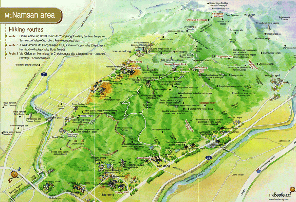
Click the map to view it in a larger size.
How to get there?
You could take a taxi, but I’d recommend taking the local bus since it’s so close to town and the buses are so cheap and frequent.
From the local bus terminal in town, take either the 500, 505, 506, 507 or 508 bus and get off at the Samneung Royal Tombs (there will be an English announcement for this stop).
When returning, simply wait at one of the bus stops on the other side of the road and catch the next bus coming through as I believe they all take you back to Gyeongju.
As always, confirm these details at the Tourist Information Centre in town just to be sure!
How much does it cost?
It’s free!!
How long does it take?
It took us around 4.5hrs to complete the loop, but as mentioned, there are numerous trails you can follow. Many people simply reach the summit and then return back along the same track, whereas others do the Jeolgol Valley loop. It’s up to you!
Photography tips?
- We visited in late June and found the conditions to be very hazy. While this was interesting in itself, I suspect that autumn would bring much better light, and the foliage would look sensational as a backdrop to the numerous statues, carvings and pagodas!
- Late in the day will bring good light as the sun approaches the horizon. Just make sure you can get back to the main road before it’s dark, or take a head lamp with you.
Where to stay?
We had the penthouse suite (complete with private moon-roof!) at the Sugar Hotel; the strangest, cheapest, most incredible place we think we’ve ever stayed!! For more info on this awesome accommodation have a read of our review here. To have a closer look, drop by Booking.com.
More information?
Drop by the Visit Korea website, here.